New type of volcanic bomb uncovered on Ascension Island

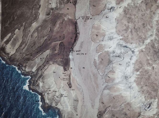
Geological mapping uncovered some unusual volcanic rocks to the west of White Horse. These dense glassy basaltic bombs are very unusual and so far are only known here on Ascension. Normally basaltic bombs are full of bubbles (trapped magmatic gas), but these are almost entirely free of bubbles. They landed hot as a sticky liquid (like tar) (top photo) and dribbled down into the gaps between the bubbly bombs beneath them (middle photo). The dribbles have beautiful droplet shapes (bottom photo). Work is underway to understand how they form.

Why are these interesting?

These new bombs can be analysed to provide information on processes that happen during volcanic eruptions. This may tell us how the magma behaved under the ground or at the surface and how changes in magma properties affected the nature of an eruption.

new volcanic bomb

Unusual glassy volcanic bombs found on Ascension

New geological map of Ascension Island being prepared

Work has started on a new geological map of Ascension Island by staff at the British Geological Survey and Durham University. Mapping is being achieved using satellite imagery and ground-truthing fieldwork. It requires the scientists to pore over every rock on the island and is providing many new insights into Ascension Island’s volcanic past. So far fieldwork has focused on Upper Valley Crater, Northeast Bay, Cricket Valley, Weatherpost, and Devil’s Inkpot. Work will continue next year around the south and west sides of Green Mountain. The map will be published digitally by the British Geological Survey.

Why do we need a geological map?

Geological maps provide information on the distribution of volcanic deposits, such as lavas, layers of ash and pumice, and on the location of the vents and craters for individual eruptions. This can help when considering the nature and location of future eruptions on the island. Geological maps also act as starting points for geological research and scientific studies by providing researchers with accurate spatial information on volcanic rocks. Geological maps are dynamic sources of information and as new research happens they can be updated and modified.

printout of satelite photo used in the field for geological mapping

Printout of satelite photo used in the field for geological mapping.

August 2017 – Goldschmidt 2017 Conference

In August 2017, Darren, Katie and Ben attended Goldschmidt 2017 in Paris. Goldschmidt is one of the foremost annual, international conferences on geochemistry and related subjects. Each year, the week-long conference brings together thousands of scientists from throughout the world to talk about subjects including the origin of the Earth and planets, the chemical processes that have shaped Earth over time, the search for new resources, and the environmental challenges facing today’s world. At the conference, Darren convened a session about timescales of crustal processes, and Katie presented a talk about the team’s research and findings entitled “1 million years of volcanism on Ascension Island: insights from stratigraphy, 40Ar/39Ar dating and petrology”. Both the session and the talk were well attended and interest in Ascension geology was strong. After the conference the team even managed to find a bit of time to do some sightseeing and sample the delights of French patisserie.

IMAGE_0__1493223406307

December 2016 – Successful NERC Facilities grant!

We are excited to have been awarded a NERC Isotope Geosciences Facilities Steering Committee grant to enable us to date some extra Ascension samples! The grant was awarded to Jenni, Darren and Katie so that they can investigate, in more detail, the timing and frequency of explosive eruptions on Ascension, using the 40Ar/39Ar dating method, linked to the detailed fieldwork that has already been carried out.

nerc-logo-115

November 2016 – Cities on Volcanoes 9 Conference

In November 2016, Jenni, Katie and Anna attended Cities on Volcanoes 9, which was held in beautiful Puerto Varas, Chile. The biannual Cities on Volcanoes conference aims to provide a link between volcanologists and emergency managers, enabling them to exchange ideas and promote multi-disciplinary applied research involving physical and social scientists and city officials. Katie presented two posters about her Ascension research, one on the island’s eruptive history and one about 40Ar/39Ar geochronology of young eruptions. During the conference, the team enjoyed a field trip to visit deposits from the 2016 Calbuco eruption and appreciated hearing from villagers sharing their experiences of the eruption.

IMG_20161120_175920902

Picturesque views from near the conference centre: snow-capped Osorno and Calbuco volcanoes